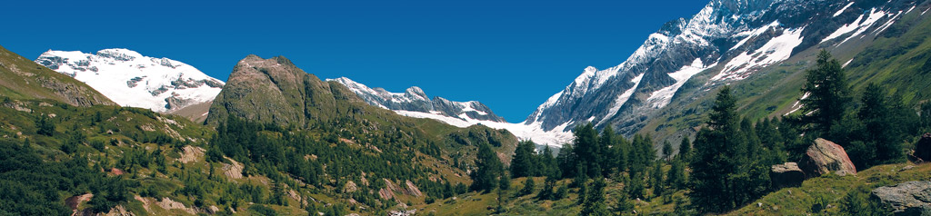
Wanderkarte mit vielen touristischen Informationen, Wanderwegen mit Marschzeiten und Richtung. Spezielle Wege der Wasserfälle. Bergwege und Bergstrecken. Viele Sehenswürdigkeiten. Lauberhornabfahrt. Erstes UNESCO Weltnaturerbe der Alpen: Jungfrau Aletsch Bietschhorn Gebiet.
Carte de pédestre avec beaucoup d'informations touristiques, des sentiers pédestres avec le temps et la direction de Mars. Des manières spécifiques de cascades. Sentiers de randonnée et de montagne. De nombreuses attractions touristiques. Lauberhorn. Premier site du patrimoine mondial de l'UNESCO dans les Alpes: la région Jungfrau-Aletsch-Bietschhorn.
Carta escursionistica con un sacco di informazioni turistiche, itinerari per escursioni con il tempo e la direzione di marcia. Modi specifici di cascate. Sentieri escursionistici e percorsi montani. Molte attrazioni turistiche. Lauberhorn. In primo luogo patrimonio mondiale dell'UNESCO nelle Alpi: Jungfrau-Aletsch-Bietschhorn zona.
Hiking map with lots of tourist information, walking trails with time and direction of march. Specific ways of waterfalls. Hiking trails and mountain routes. Many tourist attractions. Lauberhorn. First UNESCO World Heritage Site in the Alps: Jungfrau-Aletsch-Bietschhorn area.
行進の時間と方向でトレイルを歩いて観光情報の多くが付いているハイキングマップ、。滝の具体的な方法。ハイキングコースや山のルート。多くの観光スポット。ラウバー。アルプス初のユネスコ世界遺産:ユングフラウ - アレッチ - ビーチホルンのエリア。